
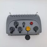
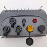
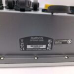
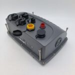
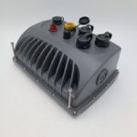
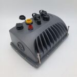

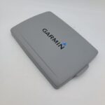
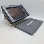
GARMIN GPSMAP 5008 Chartplotter MFD Garmin Network – PERFECT! GUARANTEE!
USD949.05
- Condition: Used
- Shipping Info: Fast worldwide shipping
- Return Info: 30-day return policy
- Warranty Info: 90-Day
![]()
Out of stock
Description
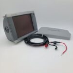
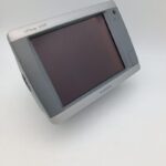
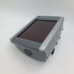
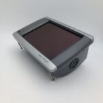
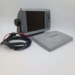
GARMIN GPSMAP 5008 Chartplotter MFD Garmin Network – GUARANTEE! TOUCHSCREEN
Works perfectly, fully tested with guarantee.
Full 1 year warranty!
********
The GPSMAP 5008 features an unprecedented touchscreen interface, along with a satellite-enhanced worldwide basemap and an 8.4″ (21.3 cm) screen that makes navigation as easy as pointing your finger. By connecting to the Garmin Marine Network, you can add sonar and radar. For even more advanced features, you can add the optional BlueChart® g2 Vision® card (sold separately).
View Detailed Graphics and Video
The GPSMAP 5008 features a worldwide basemap with high-quality satellite images in place of more traditional maps. For even more detail, you can add maps easily with the SD™ card slot without having to connect to a computer. To keep tabs on your engine room or other area of your vessel, you can connect a live video feed with the 5008’s video input/output options.
Add Extras with BlueChart g2 Vision
With the optional BlueChart g2 Vision SD card, you can add a whole new dimension of exceptional features to your chartplotter.
MarinerEye view and FishEye view provide you a 3-D perspective of map information, both above and below the waterline.
High-resolution satellite images and aerial photographs help you orient yourself in unfamiliar areas.
Auto Guidance technology searches through all relevant charts to create a route you actually can follow — one that avoids obstacles, shallow water, buoys and other obstructions.
Connect to the Garmin Marine Network
The 5008 connects easily to the high-speed Garmin Marine Network, so you can interface with additional MFDs and add remote sensors. Once connected, you can share information between the 5008 and other chartplotters on your boat. You also can add high-powered radar, sonar and XM satellite weather and radio to your system.
****
General
DIMENSION10.1″ x 6.8″ x 4.2″ (25.7 x 17.3 x 10.7 cm)
DISPLAY SIZE
6.8″ x 5.1″; 8.4″ diagonal
(17.1 x 13 cm; 21.3 cm diagonal)
DISPLAY RESOLUTION640 x 480 pixels
DISPLAY TYPETouchscreen VGA display
WEIGHT6.0 lbs (2.72 kg)
WATERPROOFIPX7
MOUNTING OPTIONSBail or flush
Maps & Memory
ACCEPTS DATA CARDS1 SD™ card
WAYPOINTS1,500
NAVIGATION ROUTES20
Sensors
NMEA 2000 COMPATIBLE
NMEA 0183 COMPATIBLE
Chartplotter Features
AIS
DSC
GSD BLACK BOX SONAR SUPPORT
WIRELESS REMOTE COMPATIBLE
Connections
CONNECTIONS NMEA0183 INPUT PORTS4
VIDEO INPUT PORTS2 – RCA composite
VIDEO OUTPUT PORTS1 – VGA
GARMIN MARINE NETWORK PORTS3
*****
GPSMAP 5008
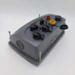
Flush mount
Bail mount
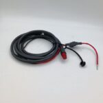
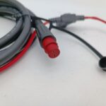
Power cable
NMEA 0183 cable
Protective front cover
Owner’s manual
Installation instructions
Additional information
| Weight | 0.0 g |
|---|---|
| Brand | Garmin |
| Warranty | 90 Day |
| Manufacturer Part Number | 010-00593-00 |
| Country/Region of Manufacture | Taiwan |
| Condition | Used |
Related products
-
NASA MARINE CLIPPER PASSPORT COMPASS REPEATER NMEA0183 – NEW IN BOX!
USD99.00Out of stock. Join the waitlist to be notified when this product becomes available. -
SILVA STAR NAV REPEATER AAL Instrument Display v 1.01 – VERY RARE! WARRANTY!
USD299.00Out of stock. Join the waitlist to be notified when this product becomes available.