


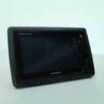
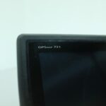
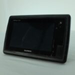
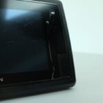

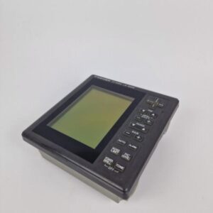
GARMIN GPSMAP 721 MFD Touchscreen Chartplotter NMEA2000 GPS
USD569.05
Out of stock
Want to be notified when this product is back in stock?
Description
GARMIN GPSMAP 721 MFD Touchscreen Chartplotter NMEA2000
Works perfectly, fully tested with guarantee.
NOTE: Crack on the side of the display. Some scratches as can be seen on the photos.
You will receive what you can see in the photos.
****
An Amazing Chartplotter with a 7-inch Touchscreen Display
7-inch WVGA touchscreen display with pinch-to-zoom
10 Hz GPS/GLONASS receiver
NMEA® 2000 and wireless connectivity
Compatible with BlueChart® g2 Vision and BlueChart® g2 mapping
GPSMAP 721
GPSMAP 721 allows for easy visibility, day or night. Whether it is flat-, flush- or gimble-mounted, it will be the focal point of your helm. It has media integration and autopilot compatibility, radar support, and NMEA 2000 and wireless connectivity. It includes our hallmark user-friendly interface as well as a worldwide basemap.
Super-fast 10 Hz GPS/GLONASS
With the integration of a 10 Hz GPS/GLONASS receiver, the 721 refreshes position and heading up to 10 times per second. It displays constant and fluid on-screen location and proves to be incredibly accurate when marking and navigating to any one of 5,000 user-created waypoints.
Add Extras with BlueChart g2 Vision
With the optional BlueChart g2 Vision SD™ card, you can add a whole new dimension of exceptional features to your chartplotter.
MarinerEye view and FishEye view provide a 3-D perspective of map information, both above and below the waterline.
High-resolution satellite images and aerial photographs help you orient yourself in unfamiliar areas.
Auto Guidance technology searches through all relevant charts to create a route you can actually follow — one that avoids obstacles, shallow water, buoys and other obstructions.
Special Sailing Features
Supported sailing features include laylines, enhanced wind rose, heading and course-over-ground lines, true wind data fields and tide/current/time slider. Gauge displays are designed to provide important need-to-know information at a glance, including true and apparent wind angle, set and drift, true or apparent wind speed, horizontal or vertical graphs, and a data bar with customizable data fields.
It also has wireless connectivity, giving you the opportunity to connect and access marine-specific apps via smartphone or tablet.
Compatible with gWind Transducers
Garmin gWind, gWind Wireless and gWind Race transducers feature twin-fin technology with 3-bladed propeller. Connect to the NMEA 2000 and compatible Garmin chartplotters via the GND 10 black box bridge.
NMEA 2000 Support
This combo allows you to add more capabilities to your boat. It provides NMEA 2000 support so you can see valuable information on your screen for Garmin autopilot, engine data and more.
View and Control Your Device From a Smartphone or Tablet
Garmin Helm™ allows you to view and control your compatible Garmin chartplotter from an iPhone® or iPad® or phone, or phone or tablet using Android™ — while providing enhanced situational awareness for the mariner. Easily switch between portrait and landscape mode to accommodate mounting preferences. Using your iPhone or iPad, you can even record a movie of your chartplotter screen to share with friends and family. Download from the App Store™ or Google Play™ today.
Get Your Apple® Device Onboard with BlueChart® Mobile
With BlueChart Mobile, a free app downloaded from the App Store, you can plan marine routes on your iPad or iPhone then wirelessly transfer them to your boat’s compatible networked Garmin chartplotter. Even if you don’t have a Garmin chartplotter, you can still take advantage of the tremendous features of BlueChart on your Apple device.
Enhanced Auto Guidance
Just enter the location where you want to go and patented Garmin Auto Guidance technology instantly searches through relevant charts to create a safe virtual pathway on the display that helps you avoid low bridges, shallow water and other charted obstructions en route.
Better still, with enhanced Version 2.0, you now have access to even more features and capabilities. You’re able to adjust the calculated Auto Guidance pathway by inserting “via” points at interim stops or landmarks along your desired route. You can easily review hazard points along your calculated path. And you can even engage your compatible Garmin autopilot to follow the Auto Guidance route, automatically. Other 2.0 enhancements give you the ability to calculate arrival times at any point on your route (great for timing arrivals to correspond with bridge openings and other time-critical events). Better still, you can now save your plotted Auto Guidance paths for future navigation by backing them up on an SD™ card with your BlueChart® g2 Vision® or Lake Vü™ HD Ultra cartography¹.
GPX Waypoints Transfer
If you have waypoints, tracks or frequently used routes stored on another manufacturer’s GPS product – or on a Garmin handheld device – now it’s easier than ever to transfer those items to your new Garmin chartplotter, via industry-standard GPX software formatting. GPX is an open standard format for GPS data exchange across platforms and applications. With this easy-to-use interface technology, Garmin has taken “no waypoint left behind” to a whole new level of trade-up convenience.
Panoptix™ Down Transducer
With 1 Panoptix Down transducer, you get 3 remarkable views, allowing you to actually see fish and bait swimming around under your boat – in real time. You can even see fish in the water column in 3-D, from the bottom to the surface. You can be stationary yet still see things in 3-D below your boat.
LIVEVÜ DOWN
Shows real-time moving sonar images below the boat. This screen shows bait drop echo trail movement in purple with sonar history data at left.
REALVÜ 3-D DOWN
Scans the area below the boat from front to back and side to side. This screen shows a school of fish sitting against the back side of vertical face, on Pport side of boat 35 feet deep.
REALVÜ 3-D HISTORICAL
Scrolls through the data as the boat moves to show the history of entire water columns – from the bottom to the surface and all of the fish in between. This screen shows the boat passing over a stream channel with a school of fish between 30 to 40 feet.
Panoptix Forward Transducer
One Panoptix Forward transducer provides 2 impressive views, even while your boat is stationary. It shows the bottom plus fish and bait swimming in the water column in front of your boat – in real time. You can even see your lure as you reel it in. You can also get 3-D views of fish and structure in front of your boat.
LIVEVÜ FORWARD
Updates are provided with a single ping, providing real-time moving images of what’s in the water. This screen shows a large target (a diver) approaching the boat.
REALVÜ 3-D FORWARD
Digitally scans the area in front of the boat, creating a forward-looking 3-D view of the bottom, structure and fish. This screen shows fish targets at 10 feet and drawing bottom depth of 20 feet.
Create your own HD maps
Quickdraw Contours is a free, easy-to-use software feature that is already installed on your Garmin. It instantly creates your very own personalised HD fishing maps with 1 foot contours. Tailor them to fit your needs. They’re your maps. You own them. Keep the data to yourself or share it with the Quickdraw Community on Garmin Connect™. There’s no special surveying expertise required. You just fish while it creates maps. You don’t have to wait around or send your files away like other mapping software requires — your results appear instantly. Use with any Garmin Panoptix™, any HD-ID™, any CHIRP-enabled, Garmin ClearVü™ transducer or NMEA 2000®-compatible depth transducer. Have more than 1 sonar device installed onboard? Quickdraw Contours automatically selects the most capable sonar device to provide the very best results for you!
Additional information
| Weight | 0.0 g |
|---|---|
| Brand | Garmin |
| Warranty | 1 Year |
| Manufacturer Part Number | GPSMAP 721 |
| Country/Region of Manufacture | Taiwan |
| Condition | Used |
Related products
-
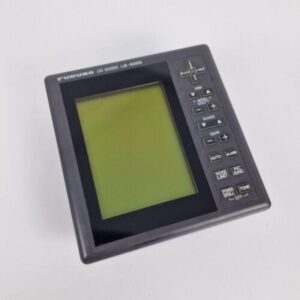
FURUNO LS-6000 LCD SOUNDER 50kHz LS6000 NMEA0183 Echo Fishfinder
USD299.00Out of stock. Join the waitlist to be notified when this product becomes available. -

FURUNO 17″ 2kW RSB-0067 Radome for M821 or 1721 MARK-2 w/Cable – PERFECT!
USD499.00Out of stock. Join the waitlist to be notified when this product becomes available. -

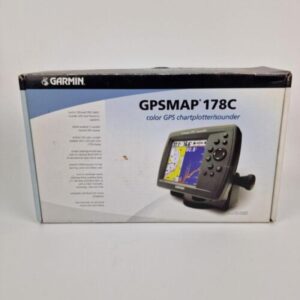
GARMIN GPSMAP 178C SOUNDER Chartplotter INTERNAL GPS Transducer BRAND NEW IN BOX
USD599.00Out of stock. Join the waitlist to be notified when this product becomes available.


