Garmin GPSMAP 7412 Touch MFD Chartplotter Panoptix Down FWD SONAR RADAR NMEA2000
USD2,899.00
Out of stock
Want to be notified when this product is back in stock?
Description
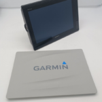
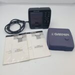
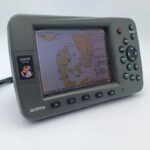
Garmin GPSMAP 7412 Touch Display MFD Chartplotter
Professionaly refurbished with full warranty.
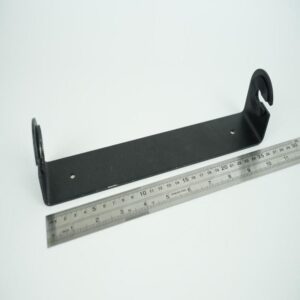
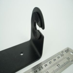
You will receive what you can see in the photos.
12-inch Fully Network Capable Chartplotter
12-inch multi-touch widescreen display (1280 x 800 WXGA) with worldwide basemap
High-sensitivity internal 10 Hz GPS/GLONASS
Fully network capable for Garmin Marine Network and NMEA 2000®, plus NMEA 0183 support
Supports GSD™ premium sonar and GCV™ scanning sonar modules
Advanced sailing and sail racing features
Designed for cruisers, sailors and sailing racers who demand high performance, ease of operation and feature integration, the GPSMAP 7412 chartplotter with 12-inch multi-touch widescreen display has a 10 Hz internal GPS that updates position and heading 10 times per second. It is fully network capable, including the Garmin Network and NMEA 2000, and offers the conveniences of built-in Wi-Fi® connectivity.
Garmin Marine Network and NMEA 2000 Support
Full-network compatibility allows you to add more capabilities to your boat. GPSMAP 7412 supports radar, autopilot, instruments, multiple screens, FUSION-Link, sensors, remote sonar modules, digital switching, thermal cameras, GRID rotary knob, joystick and keypad control, and more.
Add Array or Dome Radar
You can add your choice of Garmin marine radar, including our powerful xHD2 open array radars or xHD dome radars that pairs ease of use with advanced open array features.
Network Sharing
GPSMAP 7412 allows you to share features with other compatible GPSMAP units, such as radar, GCV 10 DownVü and SideVü scanning sonar, GSD 24, GSD 25 and GSD 26 sonar modules, supplemental maps, and user data, including waypoints, routes and tracks. User data entered into 1 chartplotter can be automatically synced with other chartplotters in a network.
Heading and Position Refreshed 10 Times Per Second
Fast, responsive 10 Hz GPS/GLONASS refreshes your position and heading 10 times each second to make your movement on the screen more fluid. It makes dropping up to 5,000 accurate waypoints — and finding your way back to them — quick and easy.
Special Sailing Features
Supported sailing features include laylines, enhanced wind rose, heading and course-over-ground lines, true wind data fields and tide/current/time slider. Gauge displays are designed to provide important need-to-know information at a glance, including true and apparent wind angle, set and drift, true or apparent wind speed, horizontal or vertical graphs, and a data bar with customizable data fields.
Compatible with gWind™ Transducers
Garmin gWind, gWind Wireless and gWind Race transducers feature twin-fin technology with 3-bladed propeller. Connect to the NMEA 2000 and compatible Garmin chartplotters via the GND™ 10 black box bridge.
Black Box Interface
The GND 10 black box interface seamlessly integrates Nexus instruments and sensors with the Garmin family. It converts data between the Nexus network and NMEA 2000 to provide trouble-free compatibility between Nexus and Garmin products.
Upgrade with the Best Maps on the Water
Two SD™ card slots provide expandable memory for accessory map purchases, such as LakeVü HD, LakeVü HD Ultra or BlueChart® g2 or BlueChart g2 Vision.
FUSION-Link Entertainment System
Enjoy the ability to control all compatible FUSION-Link-enabled audio systems directly from your compatible chartplotter display.
The Ultimate Connected Boating App
Built in Wi-Fi gives you access to the free all-in-one ActiveCaptain® app, so you can manage your marine experience from nearly anywhere. It creates a simple yet powerful connection between your compatible mobile device and your Garmin chartplotter, charts, maps and the boating community. Wherever you are, you’ll have unlimited access to your cartography, the ability to purchase new maps and charts and access to the Garmin Quickdraw™ Contours Community. Stay connected with smart notifications on your chartplotter screen. You can also plan a trip or prefish a lake, and ActiveCaptain will automatically sync with your chartplotter. Even get notifications for software updates, and decide when to download them on your device.
Enhanced Auto Guidance
Just enter the location where you want to go and patented Garmin Auto Guidance² technology instantly searches through relevant charts to create a virtual pathway on the display that helps you avoid low bridges, shallow water and other charted obstructions en route.
Better still, with enhanced Version 2.0, you now have access to even more features and capabilities. You’re able to adjust the calculated Auto Guidance pathway by inserting “via” points at interim stops or landmark
Additional information
| Weight | 2.0 g |
|---|---|
| Brand | Garmin |
| Warranty | 1 Year |
| Manufacturer Part Number | 010-01307-10 |
| Country/Region of Manufacture | Taiwan |
| Condition | Remanufactured |