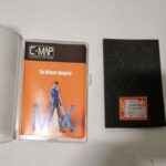


C-MAP MAX Wide EM-M976 South-West Europe C-CARD f/Raymarine Raytheon
USD189.05
1 in stock
Description
C-MAP MAX Marine Charts C-CARD C-MAP MAX Wide EM-M976 South-West European Coasts f/Raymarine Raytheon Standard Horizon
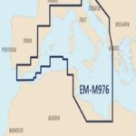
The C-MAP chart EM-M976 covers the south-western Mediterranean coast. This maps the Strait of Gibralta through Algeria Tunisia the Ionian and Adriatic Seas all of Italy and the southern coasts of France and Spain.
Works with several different chartplotters and MFDs
Additional information
| Weight | 0.0 g |
|---|